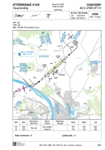


LFDW - Chauvigny
Located in Chauvigny, France
ICAO - LFDW, IATA -
Data provided by AirmateGeneral information
Coordinates: N46°35'0" E0°38'32"
Elevation is 442 feet MSL.
Magnetic variation is 0.64° East View others Airports in Poitou-Charentes
Operational data
Special qualification required
Current time UTC:
Current local time:
Weather at : LFBI - Poitiers Biard ( 26 km )
TAF: TAF LFBI 252300Z 2600/2624 21006KT CAVOK TEMPO 2606/2609 4000 -RA BKN008 TEMPO 2610/2620 3000 SHRA BKN020CB PROB30 TEMPO 2614/2618 20015G25KT TSRA
Communications frequencies: [VIEW]
Runways:
| RWY identifier | QFU | Length (ft) | Width (ft) | Surface | LDA (ft) |
| 05 | 48° | 2428 | 262 | GRASS | 2165 |
| 23 | 228° | 2428 | 262 | GRASS | 2280 |
Airport contact information
Address: Chauvigny France
