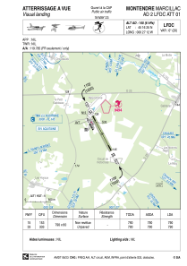


LFDC - Montendre Marcillac
Located in Montendre, France
ICAO - LFDC, IATA -
Data provided by AirmateGeneral information
Coordinates: N45°16'25" W0°27'12"
Elevation is 145 feet MSL.
Magnetic variation is 0.39° East View others Airports in Aquitaine
Operational data
Special qualification required
Current time UTC:
Current local time:
Weather at : LFBG - Cognac Chateaubernard ( 44 km )
METAR: LFBG 242330Z AUTO 25004KT 9999 SCT046 BKN054 BKN064 10/08 Q1013
TAF: TAF LFBG 241400Z 2415/2515 28008KT 9999 BKN040 TEMPO 2415/2515 4000 -SHRA BKN035TCU
Communications frequencies: [VIEW]
Runways:
| RWY identifier | QFU | Length (ft) | Width (ft) | Surface | LDA (ft) |
| 15 | 153° | 2592 | 197 | GRASS | 2592 |
| 33 | 333° | 2592 | 197 | GRASS | 2592 |
Airport contact information
Address: Montendre France

