


LFAU - Vauville
Located in , France
ICAO - LFAU, IATA -
Data provided by AirmateGeneral information
Coordinates: N49°37'22" W1°49'48"
Elevation is 458 feet MSL.
Magnetic variation is -0.37° East View others Airports in Lower Normandy
Operational data
Special qualification required
Current time UTC:
Current local time:
Weather at : LFRC - Cherbourg Manche ( 26 km )
METAR: LFRC 252000Z AUTO 25009KT CAVOK 09/05 Q1003
TAF: TAF LFRC 251400Z 2515/2524 25010KT 9999 BKN030 PROB40 TEMPO 2518/2524 4000 -RA BKN012
Communications frequencies: [VIEW]
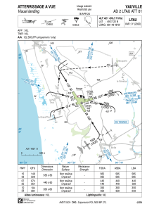
Runways:
| RWY identifier | QFU | Length (ft) | Width (ft) | Surface | LDA (ft) |
| 15 | 148° | 1854 | 197 | GRASS | 1854 |
| 33 | 328° | 1854 | 197 | GRASS | 1854 |
| 07 | 73° | 1444 | 197 | GRASS | 1444 |
| 25 | 253° | 1444 | 197 | GRASS | 1050 |
| 10 | 103° | 1148 | 197 | GRASS | 1148 |
| 28 | 283° | 1148 | 197 | GRASS | 820 |
Airport contact information
Address: France
