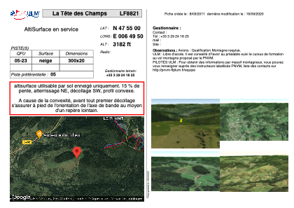


LF8821 - La Tête des Champs
Located in Le Menil, France
ICAO - , IATA -
Data provided by AirmateGeneral information
Coordinates: N47°54'60" E6°49'50"
Elevation is 3182 feet MSL.
View others Airports in Lorraine
Operational data
Special qualification required
Current time UTC:
Current local time:
Communications frequencies: [VIEW]
Runways:
| RWY identifier | QFU | Length (ft) | Width (ft) | Surface | LDA (ft) |
| 05 | 0° | 984 | 65 | SNOW | |
| 23 | 0° | 984 | 65 | SNOW |
Airport contact information
Address: Le Menil France