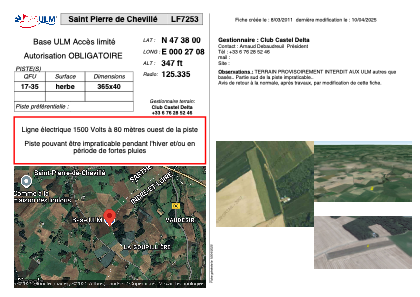


LF7253 - Saint Pierre de Chevillé
Located in Saint-Pierre-de-Chevillé, France
ICAO - , IATA -
Data provided by AirmateGeneral information
Coordinates: N47°37'60" E0°27'8"
Elevation is 347 feet MSL.
View others Airports in Centre
Operational data
Special qualification required
Current time UTC:
Current local time:
Weather at : LFOT - Tours Val De Loire ( 30 km )
METAR: LFOT 250530Z AUTO 10003KT CAVOK 05/05 Q1009 TEMPO 3000 SHRA BKN010TCU
TAF: TAF LFOT 250500Z 2506/2606 10005KT 9999 BKN030 TEMPO 2508/2513 4000 -SHRA BKN020TCU BECMG 2512/2514 24010KT TEMPO 2519/2602 4000 -SHRA BKN035TCU
Communications frequencies: [VIEW]
Runways:
| RWY identifier | QFU | Length (ft) | Width (ft) | Surface | LDA (ft) |
| 17 | 0° | 1197 | 131 | GRASS | |
| 35 | 0° | 1197 | 131 | GRASS |
Airport contact information
Address: Saint-Pierre-de-Chevillé France