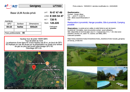


LF7033 - Gevigney
Located in Gevigney-et-Mercey, France
ICAO - , IATA -
Data provided by AirmateGeneral information
Coordinates: N47°47'49" E5°54'47"
Elevation is 720 feet MSL.
View others Airports in Franche-Comté
Operational data
Special qualification required
Current time UTC:
Current local time:
Weather at : LFSX - Luxeuil Saint Sauveur ( 34 km )
METAR: LFSX 252100Z AUTO 10005KT CAVOK 06/02 Q1006
TAF: TAF LFSX 252000Z 2521/2621 10005KT CAVOK PROB30 TEMPO 2605/2609 4900 -RA BKN014 BECMG 2609/2611 22010KT 4000 -SHRA SCT008TCU BKN020 PROB40 TEMPO 2611/2619 VRB15G25KT 2900 TSRA BKN020CB BECMG 2619/2621 12005KT 9999 NSW BKN030
Communications frequencies: [VIEW]
Runways:
| RWY identifier | QFU | Length (ft) | Width (ft) | Surface | LDA (ft) |
| 05 | 0° | 1148 | 131 | GRASS | |
| 23 | 0° | 1148 | 131 | GRASS |
Airport contact information
Address: Gevigney-et-Mercey France