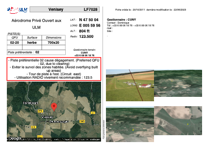


LF7028 - Venisey
Located in Venisey, France
ICAO - , IATA -
Data provided by AirmateGeneral information
Coordinates: N47°50'4" E5°59'56"
Elevation is 804 feet MSL.
View others Airports in Franche-Comté
Operational data
Special qualification required
Current time UTC:
Current local time:
Weather at : LFSX - Luxeuil Saint Sauveur ( 28 km )
METAR: LFSX 200800Z AUTO 32008KT 280V350 9999 BKN014 BKN019 BKN024 ///// Q1020
TAF: TAF LFSX 200200Z 2003/2103 31008KT 9999 BKN020 BECMG 2006/2008 BKN010 BECMG 2009/2011 BKN015TCU TEMPO 2012/2020 VRB15G25KT 4500 SHRA BKN025TCU BECMG 2020/2021 BKN020 TEMPO 2100/2103 BKN008
Communications frequencies: [VIEW]
Runways:
| RWY identifier | QFU | Length (ft) | Width (ft) | Surface | LDA (ft) |
| 02 | 0° | 2296 | 65 | GRASS | |
| 20 | 0° | 2296 | 65 | GRASS |
Airport contact information
Address: Venisey France