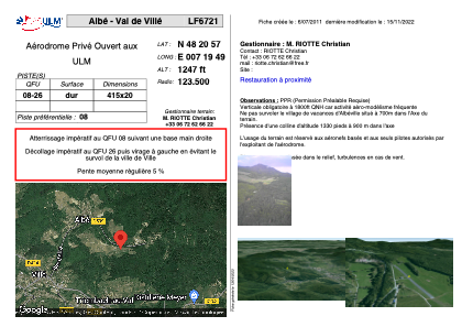


LF6721 - Albé - Val de Villé
Located in Albé, France
ICAO - , IATA -
Data provided by AirmateGeneral information
Coordinates: N48°20'57" E7°19'49"
Elevation is 1247 feet MSL.
View others Airports in Alsace
Operational data
Special qualification required
Current time UTC:
Current local time:
Weather at : LFGA - Colmar Houssen ( 27 km )
METAR: LFGA 230630Z AUTO 03008KT CAVOK 04/M01 Q1018
Communications frequencies: [VIEW]
Runways:
| RWY identifier | QFU | Length (ft) | Width (ft) | Surface | LDA (ft) |
| 08 | 0° | 1361 | 65 | ASPH | |
| 26 | 0° | 1361 | 65 | ASPH |
Airport contact information
Address: Albé France