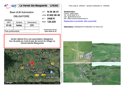


LF6355 - Le Vernet Ste Marguerite
Located in Le Vernet-Sainte-Marguerite, France
ICAO - , IATA -
Data provided by AirmateGeneral information
Coordinates: N45°36'41" E2°56'45"
Elevation is 3428 feet MSL.
View others Airports in Limousin
Operational data
Special qualification required
Current time UTC:
Current local time:
Weather at : LFLC - Clermont Ferrand Auvergne ( 26 km )
METAR: LFLC 251330Z AUTO 16003KT 080V220 9999 BKN040 BKN048 OVC060 12/04 Q1006 TEMPO 28015G25KT FEW035CB
TAF: TAF LFLC 251100Z 2512/2612 25010KT 9999 BKN040 TEMPO 2512/2521 28015G25KT -SHRA SCT035TCU PROB40 TEMPO 2513/2519 FEW035CB BECMG 2518/2521 18006KT TEMPO 2521/2606 RA FEW030TCU OVC035 BECMG 2608/2610 24008KT PROB40 TEMPO 2610/2612 4000 SHRA SCT040TCU
Communications frequencies: [VIEW]
Runways:
| RWY identifier | QFU | Length (ft) | Width (ft) | Surface | LDA (ft) |
| 07 | 0° | 984 | 0 | GRASS | |
| 25 | 0° | 984 | 0 | GRASS |
Airport contact information
Address: Le Vernet-Sainte-Marguerite France