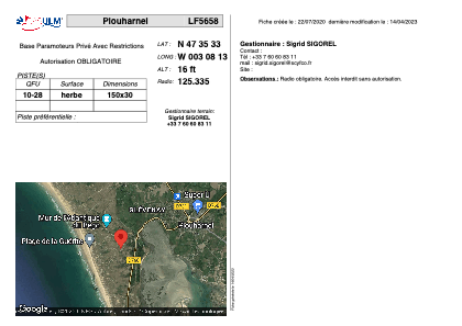


LF5658 - Plouharnel
Located in Plouharnel, France
ICAO - , IATA -
Data provided by AirmateGeneral information
Coordinates: N47°35'33" W3°8'13"
Elevation is 16 feet MSL.
View others Airports in Brittany
Operational data
Special qualification required
Current time UTC:
Current local time:
Weather at : LFRH - Lorient Lann Bihoue ( 29 km )
METAR: LFRH 201400Z AUTO 04010KT 9999 BKN049 15/05 Q1026 NOSIG
TAF: TAF LFRH 201100Z 2012/2112 06010KT 9999 BKN045 TEMPO 2012/2020 08010G20KT
Communications frequencies: [VIEW]
Runways:
| RWY identifier | QFU | Length (ft) | Width (ft) | Surface | LDA (ft) |
| 10 | 0° | 492 | 98 | GRASS | |
| 28 | 0° | 492 | 98 | GRASS |
Airport contact information
Address: Plouharnel France