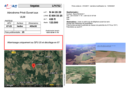


LF4752 - Segalas
Located in Ségalas, France
ICAO - , IATA -
Data provided by AirmateGeneral information
Coordinates: N44°35'29" E0°33'25"
Elevation is 436 feet MSL.
View others Airports in Aquitaine
Operational data
Special qualification required
Current time UTC:
Current local time:
Weather at : LFBE - Bergerac Dordogne Perigord ( 26 km )
METAR: LFBE 190800Z AUTO 04003KT 360V080 CAVOK 09/05 Q1024 NOSIG
TAF: TAF LFBE 190500Z 1906/2006 VRB03KT CAVOK BECMG 1912/1914 32005KT
Communications frequencies: [VIEW]
Runways:
| RWY identifier | QFU | Length (ft) | Width (ft) | Surface | LDA (ft) |
| 07 | 0° | 1476 | 98 | GRASS | |
| 25 | 0° | 1476 | 98 | GRASS |
Airport contact information
Address: Ségalas France