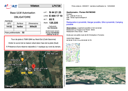


LF4738 - Villeton
Located in Villeton, France
ICAO - , IATA -
Data provided by AirmateGeneral information
Coordinates: N44°21'25" E0°17'10"
Elevation is 85 feet MSL.
View others Airports in Aquitaine
Operational data
Special qualification required
Current time UTC:
Current local time:
Weather at : LFBA - Agen La Garenne ( 32 km )
METAR: LFBA 251230Z AUTO 23007KT 160V270 9999 FEW034 BKN078 16/08 Q1008 TEMPO 4000 SHRA SCT035TCU
TAF: TAF LFBA 251100Z 2512/2521 24007KT 9999 BKN045 PROB40 TEMPO 2512/2519 4000 SHRA SCT035TCU
Communications frequencies: [VIEW]
Runways:
| RWY identifier | QFU | Length (ft) | Width (ft) | Surface | LDA (ft) |
| 14 | 0° | 984 | 82 | GRASS | |
| 32 | 0° | 984 | 82 | GRASS |
Airport contact information
Address: Villeton France