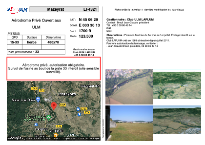


LF4321 - Mazeyrat
Located in Mazeyrat-d'Allier, France
ICAO - , IATA -
Data provided by AirmateGeneral information
Coordinates: N45°6'29" E3°30'13"
Elevation is 1700 feet MSL.
View others Airports in Auvergne
Operational data
Special qualification required
Current time UTC:
Current local time:
Weather at : LFHP - Le Puy Loudes ( 21 km )
METAR: LFHP 251800Z AUTO 26003KT 200V310 9999 SCT042 SCT049 OVC074 08/04 Q1006
Communications frequencies: [VIEW]
Runways:
| RWY identifier | QFU | Length (ft) | Width (ft) | Surface | LDA (ft) |
| 15 | 0° | 1509 | 229 | GRASS | |
| 33 | 0° | 1509 | 229 | GRASS |
Airport contact information
Address: Mazeyrat-d'Allier France