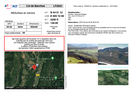


LF2623 - Col de Bacchus
Located in Plan-de-Baix, France
ICAO - , IATA -
Data provided by AirmateGeneral information
Coordinates: N44°51'11" E5°10'9"
Elevation is 3200 feet MSL.
View others Airports in Rhône Alpes
Operational data
Special qualification required
Current time UTC:
Current local time:
Weather at : LFLU - Valence Chabeuil ( 17 km )
METAR: LFLU 251130Z AUTO VRB04KT CAVOK 15/00 Q1009
Communications frequencies: [VIEW]
Runways:
| RWY identifier | QFU | Length (ft) | Width (ft) | Surface | LDA (ft) |
| 04 | 0° | 1148 | 65 | DIRT | |
| 22 | 0° | 1148 | 65 | DIRT |
Airport contact information
Address: Plan-de-Baix France