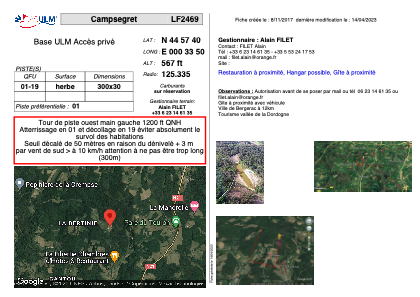


LF2469 - Campsegret
Located in Campsegret, France
ICAO - , IATA -
Data provided by AirmateGeneral information
Coordinates: N44°57'40" E0°33'50"
Elevation is 567 feet MSL.
View others Airports in Aquitaine
Operational data
Special qualification required
Current time UTC:
Current local time:
Weather at : LFBE - Bergerac Dordogne Perigord ( 16 km )
METAR: LFBE 201230Z AUTO 03012KT CAVOK 16/03 Q1022 NOSIG
TAF: TAF LFBE 201100Z 2012/2112 02010G20KT CAVOK BECMG 2016/2018 02005KT BECMG 2110/2112 01010G20KT
Communications frequencies: [VIEW]
Runways:
| RWY identifier | QFU | Length (ft) | Width (ft) | Surface | LDA (ft) |
| 01 | 0° | 984 | 98 | GRASS | |
| 19 | 0° | 984 | 98 | GRASS |
Airport contact information
Address: Campsegret France