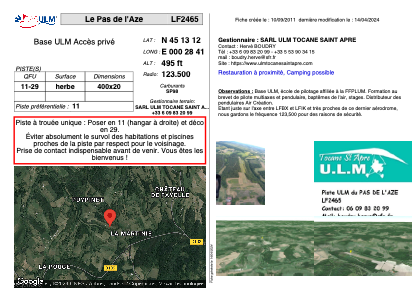


LF2465 - Le Pas de l'Aze
Located in Tocane-Saint-Apre, France
ICAO - , IATA -
Data provided by AirmateGeneral information
Coordinates: N45°13'12" E0°28'41"
Elevation is 495 feet MSL.
View others Airports in Aquitaine
Operational data
Special qualification required
Current time UTC:
Current local time:
Weather at : LFBX - Perigueux Bassillac ( 27 km )
METAR: LFBX 240200Z AUTO 00000KT CAVOK M01/M02 Q1020
Communications frequencies: [VIEW]
Runways:
| RWY identifier | QFU | Length (ft) | Width (ft) | Surface | LDA (ft) |
| 11 | 0° | 2296 | 65 | GRASS | |
| 29 | 0° | 2296 | 65 | GRASS |
Airport contact information
Address: Tocane-Saint-Apre France