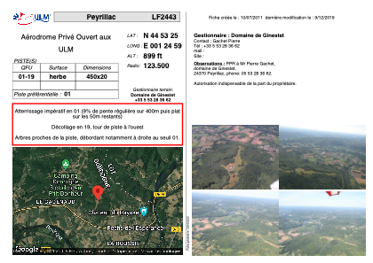


LF2443 - Peyrillac
Located in Peyrillac-et-Millac, France
ICAO - , IATA -
Data provided by AirmateGeneral information
Coordinates: N44°53'25" E1°24'59"
Elevation is 899 feet MSL.
View others Airports in Aquitaine
Operational data
Special qualification required
Current time UTC:
Current local time:
Weather at : LFSL - Brive Souillac ( 17 km )
METAR: LFSL 200930Z AUTO 01015KT 340V050 9999 FEW045 13/M02 Q1022 TEMPO 36010G20KT
TAF: TAF LFSL 200800Z 2009/2018 36005KT CAVOK TEMPO 2010/2017 36010G20KT
Communications frequencies: [VIEW]
Runways:
| RWY identifier | QFU | Length (ft) | Width (ft) | Surface | LDA (ft) |
| 01 | 0° | 1476 | 65 | GRASS | |
| 19 | 0° | 1476 | 65 | GRASS |
Airport contact information
Address: Peyrillac-et-Millac France