


KUNO - West Plains Rgnl
Located in West Plains, United States
ICAO - UNO, IATA -
Data provided by AirmateGeneral information
Coordinates: N36°52'42" W91°54'10"
Elevation is 1228 feet MSL.
Magnetic variation is 02° East View others Airports in Missouri
Operational data
Special qualification required
Current time UTC:
Current local time:
Weather
METAR: KUNO 201053Z AUTO 04004KT 10SM CLR 06/M01 A3028 RMK AO2 SLP251 T00611006 $
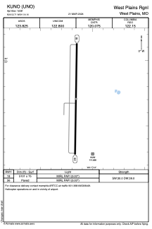
Communications frequencies: [VIEW]
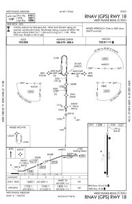
Runways:
| RWY identifier | QFU | Length (ft) | Width (ft) | Surface | LDA (ft) |
| 18 | 181° | 5101 | 75 | ASPH | |
| 36 | 1° | 5101 | 75 | ASPH |
Airport contact information
Address: West Plains United States