


KTZR - Bolton Fld
Located in Columbus, United States
ICAO - TZR, IATA -
Data provided by AirmateGeneral information
Coordinates: N39°54'4" W83°8'13"
Elevation is 904 feet MSL.
Magnetic variation is -05° East View others Airports in Ohio
Operational data
Special qualification required
Current time UTC:
Current local time:
Weather
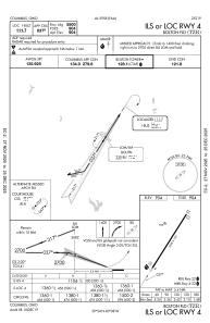
METAR: KTZR 181147Z 24004KT 10SM CLR 09/08 A3006
Communications frequencies: [VIEW]
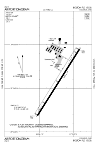
Runways:
| RWY identifier | QFU | Length (ft) | Width (ft) | Surface | LDA (ft) |
| 04 | 32° | 5500 | 100 | ASPH | |
| 22 | 212° | 5500 | 100 | ASPH |
Airport contact information
Address: Columbus United States