


KTPH - Tonopah
Located in Tonopah, United States
ICAO - TPH, IATA -
Data provided by AirmateGeneral information
Coordinates: N38°3'36" W117°5'12"
Elevation is 5430 feet MSL.
Magnetic variation is 15° East View others Airports in Nevada
Operational data
Special qualification required
Current time UTC:
Current local time:
Weather
METAR: KTPH 251956Z AUTO 30017G29KT 10SM CLR 18/02 A2992 RMK AO2 PK WND 31029/1953 SLP089 T01780017
TAF: KTPH 251720Z 2518/2618 32015G25KT P6SM VCSH SCT040 BKN080 FM260400 35012KT P6SM VCSH BKN050
Communications frequencies: [VIEW]
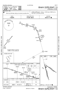
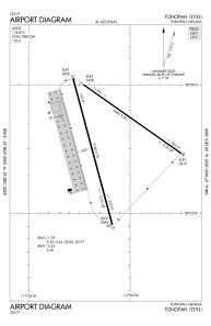
Runways:
| RWY identifier | QFU | Length (ft) | Width (ft) | Surface | LDA (ft) |
| 11 | 125° | 5660 | 50 | ASPH | |
| 29 | 305° | 5660 | 50 | ASPH | |
| 15 | 165° | 7160 | 75 | ASPH | |
| 33 | 345° | 7160 | 75 | ASPH |
Airport contact information
Address: Tonopah United States