


KTIK - Tinker Afb
Located in Oklahoma City, United States
ICAO - TIK, IATA -
Data provided by AirmateGeneral information
Coordinates: N35°24'53" W97°23'12"
Elevation is 1290 feet MSL.
Magnetic variation is 03° East View others Airports in Oklahoma
Operational data
Special qualification required
Current time UTC:
Current local time:
Weather
METAR: KTIK 192155Z AUTO 05012KT 10SM CLR 18/M00 A3006 RMK AO2 SLP184 T01831005
TAF: TAF KTIK 191700Z 1917/2023 05012KT 9999 SCT250 QNH3009INS BECMG 1920/1921 05009KT 9999 SCT250 QNH3009INS BECMG 2014/2015 05009KT 9000 -RA FEW015 OVC030 QNH3026INS BECMG 2018/2019 06012KT 9999 NSW FEW015 SCT030 BKN100 QNH3023INS TX17/1920Z TN07/2014Z
Communications frequencies: [VIEW]
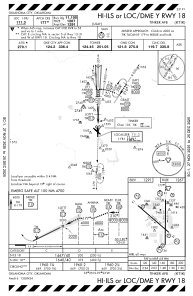
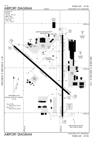
Runways:
| RWY identifier | QFU | Length (ft) | Width (ft) | Surface | LDA (ft) |
| 13 | 131° | 10000 | 200 | OTHER | |
| 31 | 311° | 10000 | 200 | OTHER | |
| 18 | 180° | 11100 | 200 | OTHER | |
| 36 | 360° | 11100 | 200 | OTHER |
Airport contact information
Address: Oklahoma City United States