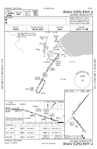


KSUW - Richard I Bong
Located in Superior, United States
ICAO - SUW, IATA -
Data provided by AirmateGeneral information
Coordinates: N46°41'23" W92°5'41"
Elevation is 674 feet MSL.
Magnetic variation is -01° East View others Airports in Wisconsin
Operational data
Special qualification required
Current time UTC:
Current local time:
Weather
METAR: KSUW 160655Z AUTO 05004KT 10SM SCT120 06/00 A3007 RMK AO2 T00550000
Communications frequencies: [VIEW]
Runways:
| RWY identifier | QFU | Length (ft) | Width (ft) | Surface | LDA (ft) |
| 04 | 37° | 5100 | 75 | ASPH | |
| 22 | 217° | 5100 | 75 | ASPH | |
| 14 | 140° | 4001 | 75 | ASPH | |
| 32 | 320° | 4001 | 75 | ASPH |
Airport contact information
Address: Superior United States
Other aviation service providers
Flight schools

Superior Flying Services, Llc.
Superior Flying Services, Llc.
calvink@superiorflying.com+1(715)394-6444