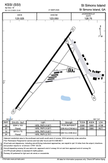


KSSI - St Simons Island
Located in St Simons Island, United States
ICAO - SSI, IATA -
Data provided by AirmateGeneral information
Coordinates: N31°9'7" W81°23'28"
Elevation is 18 feet MSL.
Magnetic variation is -05° East View others Airports in Georgia
Operational data
Special qualification required
Current time UTC:
Current local time:
Weather
METAR: KSSI 191915Z AUTO 16010G16KT 10SM CLR 28/21 A2998 RMK AO2
TAF: KSSI 191720Z 1918/2018 12010KT P6SM SCT050 SCT250 FM200300 24005KT P6SM SCT250
Communications frequencies: [VIEW]
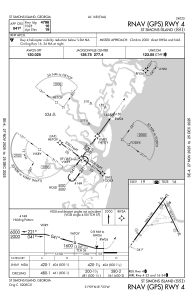
Runways:
| RWY identifier | QFU | Length (ft) | Width (ft) | Surface | LDA (ft) |
| 04 | 36° | 5584 | 100 | ASPH | 4798 |
| 22 | 216° | 5584 | 100 | ASPH | 4671 |
| 16 | 154° | 3313 | 75 | ASPH | |
| 34 | 334° | 3313 | 75 | ASPH |
Airport contact information
Address: St Simons Island United States