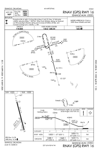


KSRE - Seminole Muni
Located in Seminole, United States
ICAO - SRE, IATA -
Data provided by AirmateGeneral information
Coordinates: N35°16'28" W96°40'31"
Elevation is 1023 feet MSL.
Magnetic variation is 06° East View others Airports in Oklahoma
Operational data
Special qualification required
Current time UTC:
Current local time:
Weather
METAR: KSRE 230855Z AUTO 17007G13KT 140V220 10SM CLR 13/08 A2991 RMK AO2
Communications frequencies: [VIEW]
Runways:
| RWY identifier | QFU | Length (ft) | Width (ft) | Surface | LDA (ft) |
| 05 | 37° | 2000 | 150 | GRASS | |
| 23 | 217° | 2000 | 150 | GRASS | |
| 16 | 166° | 5004 | 75 | ASPH | |
| 34 | 346° | 5004 | 75 | ASPH |
Airport contact information
Address: Seminole United States
