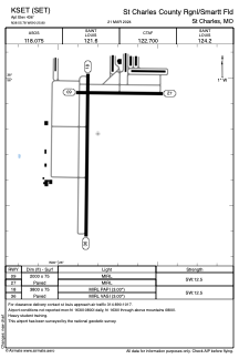


KSET - St Charles County Rgnl/Smartt Fld
Located in St Charles, United States
ICAO - SET, IATA -
Data provided by AirmateGeneral information
Coordinates: N38°55'47" W90°25'48"
Elevation is 436 feet MSL.
Magnetic variation is 01° East View others Airports in Missouri
Operational data
Special qualification required
Current time UTC:
Current local time:
Weather
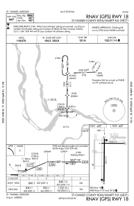
METAR: KSET 250554Z AUTO 11007KT 10SM CLR 08/06 A3024 RMK AO2 SLP239 T00830056 10150 20078 402000050 51005
Communications frequencies: [VIEW]
Runways:
| RWY identifier | QFU | Length (ft) | Width (ft) | Surface | LDA (ft) |
| 09 | 91° | 2000 | 75 | ASPH | |
| 27 | 271° | 2000 | 75 | ASPH | |
| 18 | 181° | 3800 | 75 | ASPH | |
| 36 | 1° | 3800 | 75 | ASPH |
Airport contact information
Address: St Charles United States
