


KSDF - Louisville Muhammad Ali Intl
Located in Louisville, United States
ICAO - SDF, IATA - SDF
Data provided by AirmateGeneral information
Coordinates: N38°10'27" W85°44'11"
Elevation is 500 feet MSL.
Magnetic variation is -05° East View others Airports in Kentucky
Operational data
Special qualification required
Current time UTC:
Current local time:
Weather
METAR: KSDF 191503Z 34011KT 10SM FEW010 OVC017 14/10 A3010 RMK AO2 T01390100
TAF: KSDF 191245Z 1913/2018 30009KT P6SM OVC015 TEMPO 1913/1914 31009G15KT 2SM -DZ BR OVC008 FM191600 34012G18KT P6SM BKN025 FM191800 34012KT P6SM SCT050 FM200000 35007KT P6SM SKC
Communications frequencies: [VIEW]
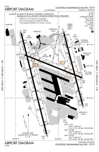
Runways:
| RWY identifier | QFU | Length (ft) | Width (ft) | Surface | LDA (ft) |
| 11 | 111° | 7251 | 150 | CONC | 6946 |
| 29 | 291° | 7251 | 150 | CONC | 7250 |
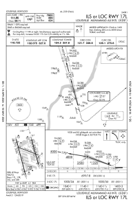
| 17R | 165° | 11887 | 150 | CONC | 10000 |
| 35L | 345° | 11887 | 150 | CONC | 10000 |
| 17L | 165° | 8578 | 150 | CONC | 7800 |
| 35R | 345° | 8578 | 150 | CONC | 7800 |
Airport contact information
Address: Louisville United States
