


KSAT - San Antonio Intl
Located in San Antonio, United States
ICAO - SAT, IATA - SAT
Data provided by AirmateGeneral information
Coordinates: N29°32'2" W98°28'9"
Elevation is 809 feet MSL.
Magnetic variation is 04° East View others Airports in Texas
Operational data
Special qualification required
Current time UTC:
Current local time:
Weather
METAR: KSAT 161851Z 00000KT 1 1/2SM BR BKN006 OVC011 23/22 A2988 RMK AO2 SFC VIS 2 1/2 SLP101 T02330217 $
TAF: KSAT 161851Z 1619/1724 VRB04KT 2SM BR OVC006 FM162000 17006KT P6SM BKN015 FM162100 14009KT P6SM SCT050 BKN200 FM170500 15006KT P6SM OVC015 FM170800 13004KT 4SM BR OVC008 FM171000 12004KT 4SM BR OVC004 FM171500 13006KT P6SM BKN010 FM171900 13010KT P6SM BKN050
Communications frequencies: [VIEW]
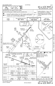
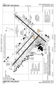
Runways:
| RWY identifier | QFU | Length (ft) | Width (ft) | Surface | LDA (ft) |
| 04 | 41° | 8505 | 150 | CONC | 8505 |
| 22 | 221° | 8505 | 150 | CONC | 8505 |
| 13L | 132° | 5519 | 100 | ASPH | 5519 |
| 31R | 312° | 5519 | 100 | ASPH | 5519 |
| 13R | 132° | 8502 | 150 | CONC | 8502 |
| 31L | 312° | 8502 | 150 | CONC | 8502 |
Airport contact information
Address: San Antonio United States
Other aviation service providers
Flight schools

Alpha Tango Flying Services, Inc.
Alpha Tango Flying Services, Inc.
alpha.tango@sbcglobal.net2108284480