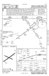
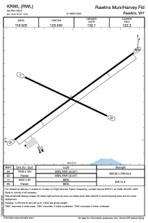


KRWL - Rawlins Muni/Harvey Fld
Located in Rawlins, United States
ICAO - RWL, IATA -
Data provided by AirmateGeneral information
Coordinates: N41°48'21" W107°12'1"
Elevation is 6816 feet MSL.
Magnetic variation is 10° East View others Airports in Wyoming
Operational data
Special qualification required
Current time UTC:
Current local time:
Weather
METAR: KRWL 231253Z AUTO 00000KT 10SM FEW070 M01/M09 A3009 RMK AO2 SLP149 T10061089
TAF: KRWL 231127Z 2312/2412 07005KT P6SM SCT150 FM231800 28010KT P6SM SCT050 BKN100 FM232100 28012G18KT P6SM VCSH BKN050 FM240600 24003KT P6SM BKN050 AMD LTD TO CLD AND VIS
Communications frequencies: [VIEW]
Runways:
| RWY identifier | QFU | Length (ft) | Width (ft) | Surface | LDA (ft) |
| 04 | 54° | 7008 | 100 | ASPH | |
| 22 | 234° | 7008 | 100 | ASPH | |
| 11 | 115° | 4322 | 60 | ASPH | |
| 29 | 295° | 4322 | 60 | ASPH |
Airport contact information
Address: Rawlins United States