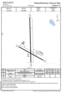


KRUT - Rutland/Southern Vermont Rgnl
Located in Rutland, United States
ICAO - RUT, IATA - RUT
Data provided by AirmateGeneral information
Coordinates: N43°31'47" W72°56'59"
Elevation is 787 feet MSL.
Magnetic variation is -15° East View others Airports in Vermont
Operational data
Special qualification required
Current time UTC:
Current local time:
Weather
METAR: KRUT 241556Z AUTO VRB06KT 10SM BKN026 BKN041 OVC049 12/06 A2977 RMK AO2 SLP077 T01170061 $
TAF: KRUT 241135Z 2412/2512 14004KT P6SM VCSH OVC070 FM241300 VRB04KT P6SM -SHRA SCT025 OVC035 TEMPO 2413/2415 6SM -RA BR BKN025 FM241500 25006KT 6SM -SHRA OVC021 FM241800 30012G21KT P6SM VCSH BKN018 OVC030 FM242000 33011G20KT P6SM BKN035 FM250100 33005KT P6SM SKC
Communications frequencies: [VIEW]
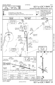
Runways:
| RWY identifier | QFU | Length (ft) | Width (ft) | Surface | LDA (ft) |
| 01 | 359° | 5304 | 100 | ASPH | 5003 |
| 19 | 179° | 5304 | 100 | ASPH | 5003 |
| 13 | 119° | 3169 | 75 | ASPH | |
| 31 | 299° | 3169 | 75 | ASPH |
Airport contact information
Address: Rutland United States