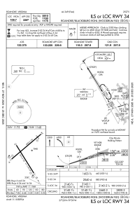
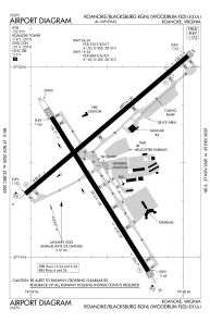


KROA - Roanoke/Blacksburg Rgnl (Woodrum Fld)
Located in Roanoke, United States
ICAO - ROA, IATA - ROA
Data provided by AirmateGeneral information
Coordinates: N37°19'32" W79°58'32"
Elevation is 1175 feet MSL.
Magnetic variation is -08° East View others Airports in Virginia
Operational data
Special qualification required
Current time UTC:
Current local time:
Weather
METAR: KROA 181754Z 32012KT 10SM CLR 29/06 A3004 RMK AO2 SLP159 T02890061 10294 20206 58009
TAF: KROA 181740Z 1818/1918 31010G19KT P6SM SKC FM182300 33006KT P6SM SKC FM191200 VRB03KT P6SM SCT025 OVC100 FM191500 15005KT P6SM -SHRA BKN025 OVC070
Communications frequencies: [VIEW]
Runways:
| RWY identifier | QFU | Length (ft) | Width (ft) | Surface | LDA (ft) |
| 06 | 49° | 6800 | 150 | ASPH | 6800 |
| 24 | 229° | 6800 | 150 | ASPH | 6010 |
| 16 | 148° | 5810 | 150 | ASPH | 5810 |
| 34 | 328° | 5810 | 150 | ASPH | 5810 |
Airport contact information
Address: Roanoke United States
