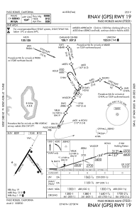
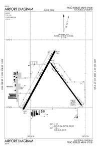


KPRB - Paso Robles Muni
Located in Paso Robles, United States
ICAO - PRB, IATA -
Data provided by AirmateGeneral information
Coordinates: N35°40'22" W120°37'37"
Elevation is 838 feet MSL.
Magnetic variation is 15° East View others Airports in California
Operational data
Special qualification required
Current time UTC:
Current local time:
Weather
METAR: KPRB 200253Z AUTO 19007KT 10SM CLR 13/10 A2993 RMK AO2 SLP134 T01280100 53009
TAF: KPRB 192351Z 2000/2024 21010KT P6SM SKC FM200400 VRB03KT P6SM SKC FM200800 VRB03KT P6SM BKN006 FM201100 VRB03KT 1SM BR VCFG VV002 FM201800 VRB03KT P6SM SKC
Communications frequencies: [VIEW]
Runways:
| RWY identifier | QFU | Length (ft) | Width (ft) | Surface | LDA (ft) |
| 01 | 29° | 6008 | 150 | ASPH | |
| 19 | 209° | 6008 | 150 | ASPH | |
| 13 | 144° | 4701 | 100 | ASPH | |
| 31 | 324° | 4701 | 100 | ASPH |
Airport contact information
Address: Paso Robles United States

