


KPHX - Phoenix Sky Harbor Intl
Located in Phoenix, United States
ICAO - PHX, IATA - PHX
Data provided by AirmateGeneral information
Coordinates: N33°26'3" W112°0'42"
Elevation is 1134 feet MSL.
Magnetic variation is 12° East View others Airports in Arizona
Operational data
Special qualification required
Current time UTC:
Current local time:
Weather
METAR: KPHX 191951Z 00000KT 10SM FEW210 FEW250 32/M04 A2980 RMK AO2 SLP073 T03171039
TAF: KPHX 191730Z 1918/2024 10005KT P6SM SKC TEMPO 1919/1921 18007KT FM192100 26009KT P6SM SKC FM200800 10005KT P6SM SKC FM202000 26006KT P6SM SKC
Communications frequencies: [VIEW]
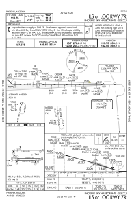
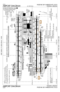
Runways:
| RWY identifier | QFU | Length (ft) | Width (ft) | Surface | LDA (ft) |
| 07R | 90° | 7800 | 150 | CONC | 7800 |
| 25L | 270° | 7800 | 150 | CONC | 7800 |
| 07L | 90° | 10300 | 150 | CONC | 10300 |
| 25R | 270° | 10300 | 150 | CONC | 10300 |
| 08 | 90° | 11489 | 150 | CONC | 10591 |
| 26 | 270° | 11489 | 150 | CONC | 11489 |
Airport contact information
Address: Phoenix United States
