


KPHP - Philip
Located in Philip, United States
ICAO - PHP, IATA -
Data provided by AirmateGeneral information
Coordinates: N44°2'55" W101°35'56"
Elevation is 2209 feet MSL.
Magnetic variation is 07° East View others Airports in South Dakota
Operational data
Special qualification required
Current time UTC:
Current local time:
Weather
METAR: KPHP 190155Z AUTO 33014KT 10SM CLR 05/M09 A3018 RMK AO2 SLP232 T00501089
Communications frequencies: [VIEW]
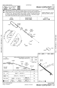
Runways:
| RWY identifier | QFU | Length (ft) | Width (ft) | Surface | LDA (ft) |
| 05 | 63° | 3588 | 120 | GRASS | |
| 23 | 243° | 3588 | 120 | GRASS | |
| 12 | 128° | 3998 | 75 | ASPH | |
| 30 | 308° | 3998 | 75 | ASPH |
Airport contact information
Address: Philip United States