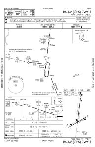
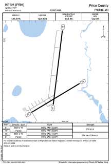


KPBH - Price County
Located in Phillips, United States
ICAO - PBH, IATA -
Data provided by AirmateGeneral information
Coordinates: N45°42'32" W90°24'9"
Elevation is 1497 feet MSL.
Magnetic variation is 00° East View others Airports in Wisconsin
Operational data
Special qualification required
Current time UTC:
Current local time:
Weather
METAR: KPBH 240555Z AUTO 04004KT 10SM CLR M02/M05 A3014 RMK AO2 T10251049 10023 21031 401531031
Communications frequencies: [VIEW]
Runways:
| RWY identifier | QFU | Length (ft) | Width (ft) | Surface | LDA (ft) |
| 01 | 7° | 5220 | 75 | ASPH | |
| 19 | 187° | 5220 | 75 | ASPH | |
| 06 | 59° | 3951 | 75 | ASPH | |
| 24 | 239° | 3951 | 75 | ASPH |
Airport contact information
Address: Phillips United States