


KOWD - Norwood Meml
Located in Norwood, United States
ICAO - OWD, IATA - OWD
Data provided by AirmateGeneral information
Coordinates: N42°11'26" W71°10'23"
Elevation is 49 feet MSL.
Magnetic variation is -15° East View others Airports in Massachusetts
Operational data
Special qualification required
Current time UTC:
Current local time:
Communications frequencies: [VIEW]
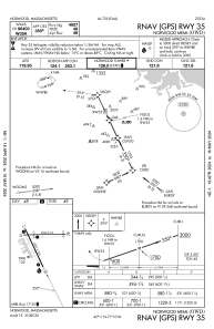
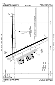
Runways:
| RWY identifier | QFU | Length (ft) | Width (ft) | Surface | LDA (ft) |
| 10 | 89° | 3995 | 75 | ASPH | 2795 |
| 28 | 269° | 3995 | 75 | ASPH | 3595 |
| 17 | 155° | 4007 | 100 | ASPH | |
| 35 | 335° | 4007 | 100 | ASPH |
Airport contact information
Address: Norwood United States
