


KNYL - Yuma Mcas/Yuma Intl
Located in Yuma, United States
ICAO - NYL, IATA - YUM
Data provided by AirmateGeneral information
Coordinates: N32°39'24" W114°36'22"
Elevation is 213 feet MSL.
Magnetic variation is 13° East View others Airports in Arizona
Operational data
Special qualification required
Current time UTC:
Current local time:
Weather
METAR: KNYL 190657Z AUTO 29005KT 10SM CLR 20/03 A2982 RMK AO2 SLP094 T02000033 403330178 $
TAF: TAF KNYL 1903/2003 18006KT 9999 SCT250 QNH2979INS FM190700 34004KT 9999 SKC QNH2979INS FM191100 25004KT 9999 SKC QNH2979INS FM191400 29004KT 9999 SKC QNH2980INS FM192000 26008KT 9999 SKC QNH2968INS AUTOMATED SENSOR METWATCH 1906 TIL 1914 T17/1913Z T34/1921Z
Communications frequencies: [VIEW]
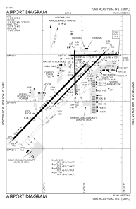
Runways:
| RWY identifier | QFU | Length (ft) | Width (ft) | Surface | LDA (ft) |
| 03R | 44° | 9240 | 150 | OTHER | 9240 |
| 21L | 224° | 9240 | 150 | OTHER | 9240 |
| 03L | 44° | 13300 | 200 | CONC | 13300 |
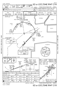
| 21R | 224° | 13300 | 200 | CONC | 13300 |
| 08 | 89° | 6146 | 150 | ASPH | 6146 |
| 26 | 269° | 6146 | 150 | ASPH | 6146 |
| 17 | 179° | 5710 | 150 | OTHER | 5710 |
| 35 | 359° | 5710 | 150 | OTHER | 5710 |
Airport contact information
Address: Yuma United States