


KNOG - Orange Grove Nalf
Located in Orange Grove, United States
ICAO - NOG, IATA -
Data provided by AirmateGeneral information
Coordinates: N27°53'49" W98°2'37"
Elevation is 257 feet MSL.
Magnetic variation is 05° East View others Airports in Texas
Operational data
Special qualification required
Current time UTC:
Current local time:
Weather
METAR: KNOG 252056Z AUTO A2984 RMK AO2 SLPNO 58030 PWINO $
Communications frequencies: [VIEW]
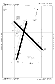
Runways:
| RWY identifier | QFU | Length (ft) | Width (ft) | Surface | LDA (ft) |
| 01 | 15° | 8000 | 198 | OTHER | |
| 19 | 195° | 8000 | 198 | OTHER | |
| 13 | 135° | 8001 | 198 | OTHER | |
| 31 | 315° | 8001 | 198 | OTHER |
Airport contact information
Address: Orange Grove United States