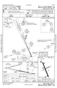
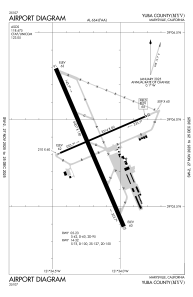


KMYV - Yuba County
Located in Marysville, United States
ICAO - MYV, IATA - MYV
Data provided by AirmateGeneral information
Coordinates: N39°5'52" W121°34'11"
Elevation is 64 feet MSL.
Magnetic variation is 16° East View others Airports in California
Operational data
Special qualification required
Current time UTC:
Current local time:
Weather
METAR: KMYV 230953Z AUTO 13011G19KT 10SM CLR 13/08 A2980 RMK AO2 SLP095 T01330083
Communications frequencies: [VIEW]
Runways:
| RWY identifier | QFU | Length (ft) | Width (ft) | Surface | LDA (ft) |
| 05 | 67° | 3314 | 60 | ASPH | |
| 23 | 247° | 3314 | 60 | ASPH | |
| 14 | 157° | 6007 | 150 | ASPH | |
| 32 | 337° | 6007 | 150 | ASPH |
Airport contact information
Address: Marysville United States
