


KMXF - Maxwell Afb
Located in Montgomery, United States
ICAO - MXF, IATA -
Data provided by AirmateGeneral information
Coordinates: N32°22'59" W86°21'57"
Elevation is 170 feet MSL.
Magnetic variation is -02° East View others Airports in Alabama
Operational data
Special qualification required
Current time UTC:
Current local time:
Weather
METAR: KMXF 191455Z AUTO 27003KT 10SM OVC016 23/19 A3008 RMK AO2 SLP188 T02290192 52009
TAF: TAF KMXF 191100Z 1911/2017 VRB06KT 9999 OVC010 QNH3005INS TEMPO 1912/1916 VRB06KT 9000 -SHRA BKN020 OVC040 BECMG 1916/1917 VRB06KT 9999 BKN040 OVC100 QNH3007INS BECMG 2008/2009 VRB06KT 9999 BKN100 QNH3007INS TX28/1921Z TN18/1911Z
Communications frequencies: [VIEW]
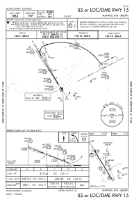
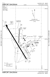
Runways:
| RWY identifier | QFU | Length (ft) | Width (ft) | Surface | LDA (ft) |
| 15 | 148° | 8008 | 150 | ASPH | |
| 33 | 328° | 8008 | 150 | ASPH | |
| 009 | 0° | 3015 | 60 | ASPH | |
| 189 | 0° | 3015 | 60 | ASPH |
Airport contact information
Address: Montgomery United States