


KMWO - Middletown Rgnl/Hook Fld
Located in Middletown, United States
ICAO - MWO, IATA -
Data provided by AirmateGeneral information
Coordinates: N39°31'54" W84°23'47"
Elevation is 650 feet MSL.
Magnetic variation is -04° East View others Airports in Ohio
Operational data
Special qualification required
Current time UTC:
Current local time:
Weather
METAR: KMWO 252155Z AUTO 03006KT 10SM CLR 16/M01 A3024 RMK AO2 T01581006
Communications frequencies: [VIEW]
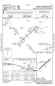
Runways:
| RWY identifier | QFU | Length (ft) | Width (ft) | Surface | LDA (ft) |
| 05 | 49° | 6100 | 100 | ASPH | |
| 23 | 229° | 6100 | 100 | ASPH | |
| 08 | 85° | 3026 | 160 | GRASS | |
| 26 | 265° | 3026 | 160 | GRASS |
Airport contact information
Address: Middletown United States
Other aviation service providers
Flight schools

Middletown Regional Flight Training Institute, Llc
Middletown Regional Flight Training Institute, Llc
flightschool@mrfti.com+1(513)217-4636