


KMVY - Martha's Vineyard
Located in Vineyard Haven, United States
ICAO - MVY, IATA - MVY
Data provided by AirmateGeneral information
Coordinates: N41°23'36" W70°36'50"
Elevation is 66 feet MSL.
Magnetic variation is -15° East View others Airports in Massachusetts
Operational data
Special qualification required
Current time UTC:
Current local time:
Weather
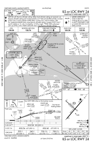
METAR: KMVY 192053Z 13010KT 10SM CLR 10/04 A3012 RMK AO2 SLP201 T01000044 56009
Communications frequencies: [VIEW]
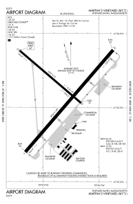
Runways:
| RWY identifier | QFU | Length (ft) | Width (ft) | Surface | LDA (ft) |
| 06 | 41° | 5504 | 100 | ASPH | 5504 |
| 24 | 221° | 5504 | 100 | ASPH | 5504 |
| 15 | 131° | 3327 | 75 | ASPH | 3327 |
| 33 | 311° | 3327 | 75 | ASPH | 3327 |
Airport contact information
Address: Vineyard Haven United States