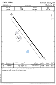


KMSV - Sullivan County Intl
Located in Monticello, United States
ICAO - MSV, IATA -
Data provided by AirmateGeneral information
Coordinates: N41°42'6" W74°47'42"
Elevation is 1403 feet MSL.
Magnetic variation is -12° East View others Airports in New York
Operational data
Special qualification required
Current time UTC:
Current local time:
Communications frequencies: [VIEW]
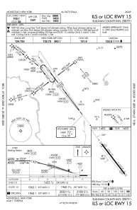
Runways:
| RWY identifier | QFU | Length (ft) | Width (ft) | Surface | LDA (ft) |
| 15 | 143° | 6298 | 150 | ASPH | 5900 |
| 33 | 323° | 6298 | 150 | ASPH | 5798 |
Airport contact information
Address: Monticello United States