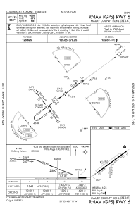
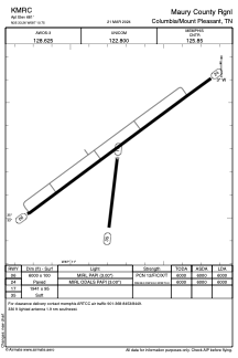


KMRC - Maury County Rgnl
Located in Columbia/Mount Pleasant, United States
ICAO - MRC, IATA - MRC
Data provided by AirmateGeneral information
Coordinates: N35°33'16" W87°10'45"
Elevation is 681 feet MSL.
Magnetic variation is -01° East View others Airports in Tennessee
Operational data
Special qualification required
Current time UTC:
Current local time:
Weather
METAR: KMRC 240530Z AUTO 20003KT 10SM CLR 14/05 A3003 RMK A01
Communications frequencies: [VIEW]
Runways:
| RWY identifier | QFU | Length (ft) | Width (ft) | Surface | LDA (ft) |
| 06 | 54° | 6000 | 100 | ASPH | 6000 |
| 24 | 234° | 6000 | 100 | ASPH | 6000 |
| 17 | 187° | 1941 | 95 | GRASS | |
| 35 | 7° | 1941 | 95 | GRASS |
Airport contact information
Address: Columbia/Mount Pleasant United States