
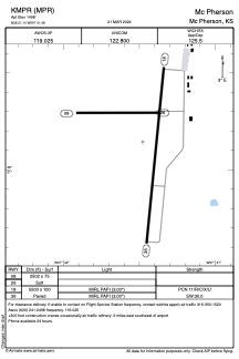


KMPR - Mc Pherson
Located in Mc Pherson, United States
ICAO - MPR, IATA -
Data provided by AirmateGeneral information
Coordinates: N38°21'9" W97°41'29"
Elevation is 1498 feet MSL.
Magnetic variation is 06° East View others Airports in Kansas
Operational data
Special qualification required
Current time UTC:
Current local time:
Weather
METAR: KMPR 251555Z AUTO 13013KT 7SM BR OVC005 14/13 A2988 RMK AO2 T01400131
Communications frequencies: [VIEW]
Runways:
| RWY identifier | QFU | Length (ft) | Width (ft) | Surface | LDA (ft) |
| 08 | 90° | 2502 | 75 | GRASS | |
| 26 | 270° | 2502 | 75 | GRASS | |
| 18 | 186° | 5503 | 100 | CONC | |
| 36 | 6° | 5503 | 100 | CONC |
Airport contact information
Address: Mc Pherson United States
