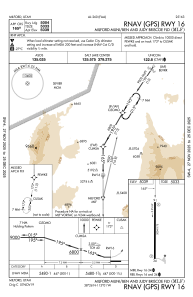
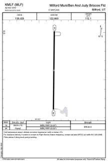


KMLF - Milford Muni/Ben And Judy Briscoe Fld
Located in Milford, United States
ICAO - MLF, IATA -
Data provided by AirmateGeneral information
Coordinates: N38°25'36" W113°0'48"
Elevation is 5042 feet MSL.
Magnetic variation is 15° East View others Airports in Utah
Operational data
Special qualification required
Current time UTC:
Current local time:
Weather
METAR: KMLF 230752Z AUTO 32004KT 10SM CLR 12/M05 A2993 RMK AO2 SLP080 T01171050
Communications frequencies: [VIEW]
Runways:
| RWY identifier | QFU | Length (ft) | Width (ft) | Surface | LDA (ft) |
| 16 | 180° | 5004 | 75 | ASPH | |
| 34 | 0° | 5004 | 75 | ASPH |
Airport contact information
Address: Milford United States