


KMHK - Manhattan Rgnl
Located in Manhattan, United States
ICAO - MHK, IATA - MHK
Data provided by AirmateGeneral information
Coordinates: N39°8'28" W96°40'19"
Elevation is 1066 feet MSL.
Magnetic variation is 04° East View others Airports in Kansas
Operational data
Special qualification required
Current time UTC:
Current local time:
Weather
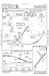
METAR: KMHK 200352Z AUTO 02008KT 10SM OVC090 12/M02 A3032 RMK AO2 SLP268 T01171022
TAF: KMHK 192321Z 2000/2024 02006KT P6SM OVC090 FM200900 04009KT P6SM OVC070
Communications frequencies: [VIEW]
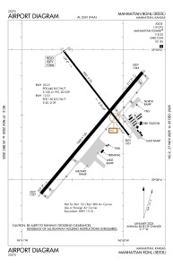
Runways:
| RWY identifier | QFU | Length (ft) | Width (ft) | Surface | LDA (ft) |
| 03 | 40° | 7000 | 150 | CONC | 7000 |
| 21 | 220° | 7000 | 150 | CONC | 7000 |
| 13 | 142° | 5001 | 75 | OTHER | 5000 |
| 31 | 322° | 5001 | 75 | OTHER | 5000 |
Airport contact information
Address: Manhattan United States
