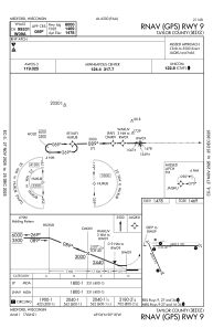


KMDZ - Taylor County
Located in Medford, United States
ICAO - MDZ, IATA - MDF
Data provided by AirmateGeneral information
Coordinates: N45°6'5" W90°18'1"
Elevation is 1478 feet MSL.
Magnetic variation is 00° East View others Airports in Wisconsin
Operational data
Special qualification required
Current time UTC:
Current local time:
Weather
METAR: KMDZ 201335Z AUTO 32015KT 10SM SCT027 OVC043 M01/M08 A3013 RMK AO2 T10091083 PWINO
Communications frequencies: [VIEW]
Runways:
| RWY identifier | QFU | Length (ft) | Width (ft) | Surface | LDA (ft) |
| 09 | 89° | 6000 | 100 | ASPH | |
| 27 | 269° | 6000 | 100 | ASPH | |
| 16 | 156° | 4435 | 75 | ASPH | |
| 34 | 336° | 4435 | 75 | ASPH |
Airport contact information
Address: Medford United States