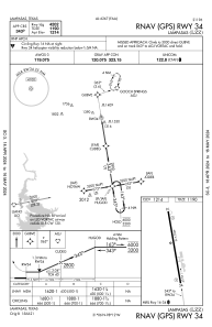
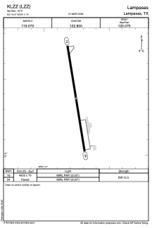


KLZZ - Lampasas
Located in Lampasas, United States
ICAO - LZZ, IATA -
Data provided by AirmateGeneral information
Coordinates: N31°6'22" W98°11'45"
Elevation is 1214 feet MSL.
Magnetic variation is 08° East View others Airports in Texas
Operational data
Special qualification required
Current time UTC:
Current local time:
Communications frequencies: [VIEW]
Runways:
| RWY identifier | QFU | Length (ft) | Width (ft) | Surface | LDA (ft) |
| 16 | 171° | 4202 | 75 | ASPH | |
| 34 | 351° | 4202 | 75 | ASPH |
Airport contact information
Address: Lampasas United States