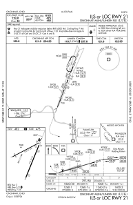
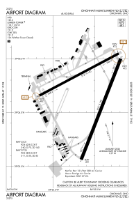


KLUK - Cincinnati Muni/Lunken Fld
Located in Cincinnati, United States
ICAO - LUK, IATA - LUK
Data provided by AirmateGeneral information
Coordinates: N39°6'12" W84°25'7"
Elevation is 483 feet MSL.
Magnetic variation is -04° East View others Airports in Ohio
Operational data
Special qualification required
Current time UTC:
Current local time:
Communications frequencies: [VIEW]
Runways:
| RWY identifier | QFU | Length (ft) | Width (ft) | Surface | LDA (ft) |
| 03R | 21° | 6101 | 150 | ASPH | 6101 |
| 21L | 201° | 6101 | 150 | ASPH | 6101 |
| 03L | 23° | 3801 | 100 | ASPH | |
| 21R | 203° | 3801 | 100 | ASPH | |
| 07 | 62° | 5127 | 100 | ASPH | |
| 25 | 242° | 5127 | 100 | ASPH |
Airport contact information
Address: Cincinnati United States
