


KLRD - Laredo Intl
Located in Laredo, United States
ICAO - LRD, IATA - LRD
Data provided by AirmateGeneral information
Coordinates: N27°32'39" W99°27'42"
Elevation is 508 feet MSL.
Magnetic variation is 05° East View others Airports in Texas
Operational data
Special qualification required
Current time UTC:
Current local time:
Weather
METAR: KLRD 192156Z 07009KT 10SM BKN049 BKN070 33/22 A2983 RMK AO2 SLP097 T03330222
TAF: KLRD 191730Z 1918/2018 11010KT P6SM FEW025 SCT250 FM192200 11015G23KT P6SM SCT250 FM200600 10008KT P6SM SCT015 BKN050 FM200800 08008KT P6SM OVC015 AMD NOT SKED
Communications frequencies: [VIEW]
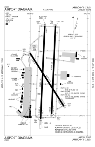
Runways:
| RWY identifier | QFU | Length (ft) | Width (ft) | Surface | LDA (ft) |
| 14 | 147° | 5927 | 150 | CONC | 5927 |
| 32 | 327° | 5927 | 150 | CONC | 5927 |
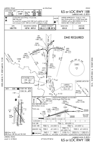
| 18L | 183° | 8236 | 150 | CONC | 8236 |
| 36R | 3° | 8236 | 150 | CONC | 8236 |
| 18R | 183° | 8743 | 150 | CONC | 8743 |
| 36L | 3° | 8743 | 150 | CONC | 8623 |
Airport contact information
Address: Laredo United States